Shapefiles power desktop GIS, while KML powers Google Earth. So at some point you need to convert a Shapefile to KML. This guide shows the quickest way. It is free, and it runs in your browser, so nothing is uploaded.
A Shapefile is really several files. They must travel together. So zip them into one .zip. Then drop the .zip into the Shapefile converter. Next, choose KML or KMZ. Finally, download the result. It all happens in your browser.
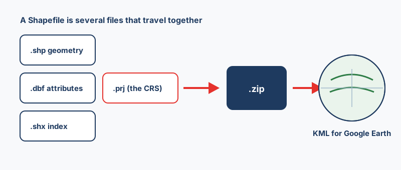
The format splits its data across files. The .shp holds geometry. The .dbf holds the attribute table. The .shx is the index. The .prj records the coordinate system. So send only the .shp, and your GIS opens nothing useful. That is why we zip the whole set.
Select the files themselves, then compress those. So do not zip the enclosing folder. A flat archive always works. Also, confirm every part shares the same base name. For example, roads.shp pairs with roads.dbf, not roads_final.dbf.
KML is always WGS84 longitude and latitude. So the converter reprojects your data for you. However, it can only do that when the .prj is present. Therefore, always include the .prj.
Without a .prj, nothing knows what the numbers mean. For example, 451234 and 5411234 are metres, not degrees. So treating them as degrees places your data far away. To fix it, set the coordinate system yourself. For instance, use EPSG:27700 for the British National Grid. You can look codes up at epsg.io.
The .dbf has no reliable encoding label. So accented characters can arrive as question marks. A .cpg file fixes this, because it declares the encoding. KML is UTF-8 throughout. Therefore clean text stays clean.
A converted shapefile lands as raw geometry with attributes. It works, but it is rarely pretty. So two small changes help the most.
Google Earth uses each placemark's name for its label. So pick a short, meaningful column, like a site name. A numeric ID makes a poor label. Also, long labels overlap when features sit close together.
Polygons convert to filled shapes. Lines convert to paths. Both sit on the ground by default, which suits parcels and roads. However, stray Z values can lift flat data above the terrain. So drop the Z values if you do not need them.
Going back is just as easy. So the KML to Shapefile converter turns a Google Earth file into a shapefile. It also pulls popup data into proper columns.
A shapefile to KML to shapefile trip is not perfectly lossless. Field names get squeezed back to ten characters. Also, mixed geometry must be split, because a shapefile holds one type. So for a lossless format, use GeoPackage instead. In short, to convert a Shapefile to KML cleanly, keep the .prj and pick a good label field.
Zip the .shp, .dbf, .shx and .prj files together, drop the archive into a browser-based shapefile converter, choose KML or KMZ, and download the result. No GIS software or account is needed, and with an in-browser tool the data is never uploaded to a server.
At minimum .shp (geometry), .dbf (attributes) and .shx (index). Always add the .prj as well, because it records the coordinate system, without it the converter cannot reproject your data to the WGS84 that KML requires.
Yes. A browser-based converter runs the same GDAL engine those programs use, compiled to WebAssembly, so no desktop install is needed. It also works offline once the page has loaded.
Almost always a missing or wrong .prj file. If the shapefile is in a projected system such as UTM or a national grid and no coordinate system is declared, the metre values get treated as degrees and the data lands far from where it should. Include the .prj, or set the coordinate system manually before converting.
KML is plain XML you can open and edit in a text editor. KMZ is that same KML zipped, so it is smaller and can bundle custom icons. Google Earth opens both; use KMZ when emailing large files.
Yes, the .dbf columns become attributes on each placemark and appear in the Google Earth popup. Note that shapefile field names are already capped at 10 characters, so any truncation you see was introduced by the shapefile format itself, not the conversion.