
How to convert CSV to GPX
- Drop the CSV of waypoints into the converter above.
- Match the latitude and longitude dropdowns to the right columns. A name column becomes each waypoint's label on the device.
- Choose GPX and convert, then copy the file to your GPS or import it into your app.
What changes when you convert CSV to GPX
| What | CSV → GPX | |
|---|---|---|
| Geometry | Changes | Points and lines transfer directly. GPX has no polygon type, so polygons are converted to their boundary as line tracks rather than being dropped. |
| Attributes | Changes | GPX has a fixed schema, so only its native fields (name, description, elevation, time) are filled. Extra columns are not written. |
| Styling & labels | Kept | Neither CSV nor GPX stores visual styling, so there is nothing to lose. Geometry and data carry straight over. |
| Coordinate system | Changes | CSV carries no coordinate system, so values are read as WGS84 longitude/latitude (EPSG:4326), which GPX requires. Set a source CRS if your data is in meters. |
| Elevation (Z) | Not stored | CSV has no 3D geometry. An elevation column, if the table has one, rides along as an ordinary attribute rather than as Z height. |
| File structure | Kept | A single, self-contained .gpx file you can move around on its own. |
What your spreadsheet needs first
A GPX waypoint amounts to two things on a device screen: a position and the label beside it. Build the sheet around that fact, one row per stop, and put the effort into the name column, because that column is written into the file beside the coordinates and becomes the label a cold thumb scrolls past on the trail.
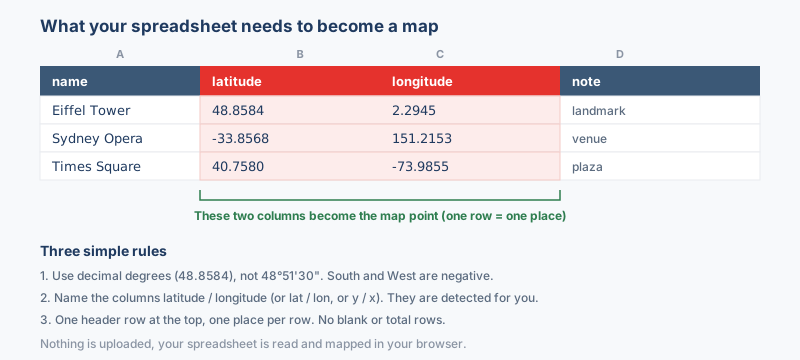
Preparing a waypoint sheet
- Write names for a three-inch screen. A handheld shows roughly a dozen characters beside each point, so
Water cache 3works where a full sentence gets cut off mid-word. - Keep coordinates in decimal degrees. Headers such as
latandlonare detected automatically, while values written as degrees and minutes need a pass through the coordinate converter before they read as numbers. - Trim the list to the trip. Convert a copy holding just the stops this outing needs, because a full database dump buries the markers that matter under hundreds that do not.
Columns for notes, dates and gear stay behind in the sheet, with one exception: a column whose header already matches a GPX field name carries over. Keep the original sheet as the master record either way, and expect a plain .csv saved from Excel, Google Sheets or a database export to convert identically.
Why convert CSV to GPX?
Field data lives in spreadsheets because rows are easy to type, sort and share, but the receiver in your hand speaks GPX. Converting turns a table of coordinates into waypoints that a Garmin, a handheld unit or a phone app treats as destinations, and the same file loads into Strava, Komoot or QGIS. The round trip is the habit worth forming: plan the stops in a sheet, convert, walk the route, then fix the sheet and convert again.
Coordinate system handling
GPX is locked to WGS84 by its specification, so whatever the sheet holds has to leave this page as decimal degrees on that datum; a Garmin trusts every coordinate it reads to be exactly that and runs no checks of its own.
The sheet itself declares nothing, which means the values are taken at face value as longitude and latitude unless a source system is chosen first. Magnitude is the quick tell: a degree value never passes 180, so coordinates running to six or seven digits are projected eastings and northings waiting on their EPSG code before the conversion can place them (how to find the code).
What to check when converting CSV to GPX
Pick your name column with care, because GPX has a fixed schema and in practice the name is what crosses over: it shows on the device screen in the field, so keep it short and recognizable. Elevation, date and note columns are not written into the GPX at all, so keep the original sheet, or a GeoJSON copy, as the full attribute table, and expect rows without a valid latitude and longitude to be skipped.
Troubleshooting CSV to GPX
- The Garmin accepts the file yet lists no waypoints. Handhelds overwrite waypoints that share a name during import, and most models cap waypoint storage around 500 or 1,000. Give every row a distinct label, split an oversized list across several files, and clear stale waypoints off the unit before loading a long one.
- Rows with comma decimals never become waypoints. Exports from software set to European number formats write 48,8566 where the converter needs 48.8566, and such cells read as text rather than coordinates. Re-save the sheet with period decimals, or run Find and Replace over the two coordinate columns before converting.
- The first stop on the list is missing from the output. A sheet without a header row loses its top line, because that line is read as column names. Insert a plain header row, name, lat and lon will do, above the data and every stop comes through.
- The stops appear out of order on the device. Most units sort waypoints alphabetically and ignore the row order of the sheet. Prefix each name with a two-digit number, 01 Trailhead through 12 Summit, and the alphabetical listing matches the day's travel sequence.
About the formats
A CSV is where field coordinates usually start life: a spreadsheet of waypoints logged by hand, pulled from a database, or exported by a sensor. GPX is what a Garmin unit, a running watch, or a navigation app actually reads. Converting bridges the two, since each CSV row with a valid latitude and longitude becomes a GPX waypoint, and numbers sitting in a spreadsheet column turn into placeable stops you can carry into the field.
Frequently asked questions
My coordinates are UTM eastings and northings, so will that work?
Yes, when you pick the matching coordinate system first; the output is reprojected to longitude and latitude on the way through.
Which apps and devices read the GPX this produces?
Garmin units, phone navigation apps, Strava, Komoot and QGIS can all open the result.
Why did the converted points land in the sea?
Latitude and longitude are swapped, or projected meters were read as degrees, so check the column pickers and convert again.
Will my rows become a connected track or separate points?
Each row becomes an individual waypoint rather than a joined track, which suits scattered stops like trailheads or sample sites. Keep the rows in travel sequence when order matters, and let a tool such as GPSBabel stitch the waypoints into a route or track afterwards.
Related converters
Ready to convert?
Drop a file and download the result in seconds. Nothing is uploaded, nothing is stored.