
How to convert Excel to CSV
- Drop the .xlsx workbook into the converter box above.
- The first worksheet's rows and headers are read exactly as they appear in the file.
- Choose CSV and convert; the download is UTF-8 text that any program, script or database import accepts.
What changes when you convert Excel to CSV
| What | Excel → CSV | |
|---|---|---|
| Geometry | Changes | Point features become X and Y columns; lines and polygons are written to a WKT geometry column, so no shape is lost in the table. |
| Attributes | Kept | Every column and full field name moves from Excel into CSV untouched. |
| Styling & labels | Kept | Neither Excel nor CSV stores visual styling, so there is nothing to lose. Geometry and data carry straight over. |
| Coordinate system | Changes | CSV stores raw coordinates without a CRS tag, so note the coordinate system separately for whoever opens the file. |
| Elevation (Z) | Not stored | Neither Excel nor CSV stores 3D geometry; elevation stays a plain column if you have one. |
| File structure | Kept | A single, self-contained .csv file you can move around on its own. |
What your spreadsheet needs first
You do not need to be a GIS expert to convert Excel to CSV. Your sheet needs just two things: a column of latitudes and a column of longitudes, and the coordinates are kept as clean X/Y columns. Everything else, names, notes, dates, ID numbers, rides along as attributes on each point.
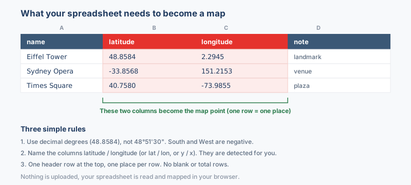
The columns that matter
- Latitude, a number between -90 and 90 (negative south of the equator). Common headers like
lat,latitudeoryare detected automatically. - Longitude, a number between -180 and 180 (negative west of Greenwich). Headers like
lon,lng,longitudeorxare picked up for you. - A name column (optional but recommended), so each point shows a readable label instead of a generic marker.
Store the coordinates as plain decimal degrees, like 33.6844 and 73.0479. If your values look like 33°41'04"N instead, convert them first with the coordinate converter. Excel to CSV works with .xlsx, .csv and Google Sheets exports; the old .xls must be re-saved as .xlsx first, and if the wrong column is picked you can fix it from the dropdowns before converting.
Why convert Excel to CSV?
Scripts, databases and data pipelines expect plain text, and many of them cannot read the binary .xlsx container at all, while almost every program ever written opens a CSV. Converting flattens one worksheet of values into comma-separated rows that pandas, a database import or a GIS coordinate importer reads without a spreadsheet program in sight. Nothing about the sheet needs to be spatial either, because this is a table-to-table conversion: an address list, a sensor log and a plain inventory table all come through the same way.
Coordinate system handling
Excel to CSV is a table conversion from start to finish, so no coordinate system is read, assigned or reprojected along the way. Every cell value is written out exactly as the workbook stores it.
A sheet that happens to hold latitude and longitude columns passes them through as ordinary numbers. The coordinate-system question only arises when the table moves on to a map format, and the converter for that step asks at that point.
What to check when converting Excel to CSV
Look at a few long coordinate cells before you convert, because if Excel has already reformatted them, the lost precision goes straight into the CSV, and a stray thousands separator will break the file the moment you map it. Remember what a flat text file can carry: formulas are written as their computed values, colors, fonts, number styles and charts are dropped, and a code such as 0730 keeps its zero only if the column was stored as text in Excel. Keep the original .xlsx whenever the styling or the other sheets still matter.
Troubleshooting Excel to CSV
- The CSV holds the wrong sheet's data. Only the first worksheet is read, so a summary tab sitting at the front shadows the data behind it. Drag the sheet you actually want into first position in Excel, save, and convert again.
- Leading zeros vanished from a code column. Excel stores 0730 as the number 730 unless the cells were formatted as text before the codes were typed. Reformat the column as text in the workbook, restore the zeros there, and run the conversion again.
- Long coordinates lost precision or carry stray separators. The CSV receives what the workbook stores, so damage from Excel's automatic reformatting travels straight through. Clean the affected cells in the workbook first, then convert a fresh copy.
- Excel mangles the CSV when you open it to check. Double-clicking the file lets Excel round long decimals, turn codes into dates and drop zeros all over again. Inspect it in a text editor instead, or import it through Data, From Text/CSV, which keeps the columns exactly as written.
About the formats
An Excel workbook is where a table gets built: typed cells, several sheets, formula columns, a little color on the header row. A CSV is the flat, single-sheet version of the same data, which is why one sheet makes one CSV and the other tabs stay behind in the workbook. Cell values and headers carry over as they appear, so what comes out is the table itself with none of the presentation, ready for pandas, a database loader or any tool that refuses an .xlsx.
Frequently asked questions
How do I export each sheet from a workbook with several tabs?
The converter reads the first worksheet, so move the sheet you want to the front and convert, then repeat for the next tab or split the tabs into files of their own. Each pass turns one sheet into one standalone CSV file.
Which programs can read the CSV that comes out?
Practically all of them, from a bare text editor to Google Sheets, a database bulk loader or a Python script. That reach is the whole point of the trip: CSV is the one tabular format with no gatekeeper.
Can I go straight to a map format instead of CSV?
Yes. When the sheet carries latitude and longitude columns, the Excel to KML and Excel to Shapefile converters read the workbook the same way and skip the CSV stop entirely.
Will my formulas and cell formatting survive in the CSV?
Formulas are written as their computed values only, and styling such as colors, date display and number formats is dropped, since CSV stores plain text and numbers. A formula returning a longitude exports as the bare number it produced, which is normally what the next tool wanted anyway.
Why does the converter reject my old .xls file?
The 1997-2003 binary .xls format is not supported, so the converter asks you to save the workbook as .xlsx first. Open the file in Excel or LibreOffice, choose Save As with the .xlsx type, and drop the fresh copy.
Related converters
Ready to convert?
Drop a file and download the result in seconds. Nothing is uploaded, nothing is stored.