
How to convert Excel to KML
- Drop the .xlsx workbook straight into the converter box above.
- Check the coordinate pickers: every column header is listed, so a wrong guess takes seconds to fix.
- Choose KML and convert, then open the file in Google Earth.
What changes when you convert Excel to KML
| What | Excel → KML | |
|---|---|---|
| Geometry | Kept | Each row with coordinates becomes a point feature. If the table has a WKT geometry column, its lines and polygons are rebuilt as real shapes. |
| Attributes | Kept | Every column and full field name moves from Excel into KML untouched. |
| Styling & labels | Changes | KML supports styling; features are written with clean default styling and a name label you can restyle in Google Earth. |
| Coordinate system | Changes | Excel carries no coordinate system, so values are read as WGS84 longitude/latitude (EPSG:4326), which KML requires. Set a source CRS if your data is in meters. |
| Elevation (Z) | Not stored | Excel has no 3D geometry. An elevation column, if the table has one, rides along as an ordinary attribute rather than as Z height. |
| File structure | Kept | A single, self-contained .kml file you can move around on its own. |
What your spreadsheet needs first
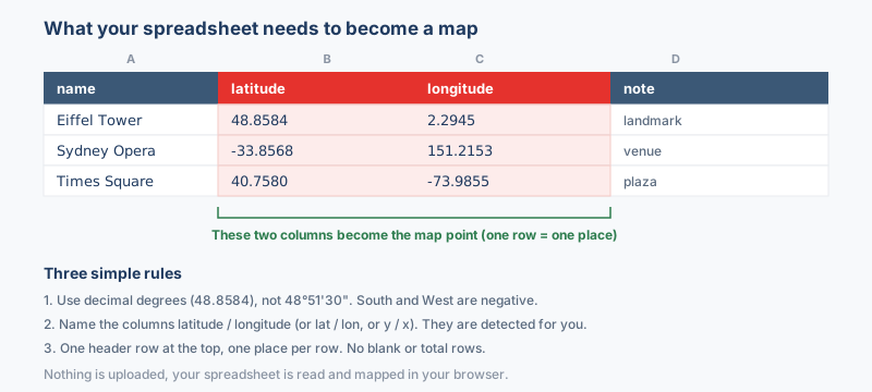
A workbook is ready for Google Earth the moment two of its columns hold decimal degrees. Nothing else needs restructuring: notes, dates and readings stay in their columns and follow the coordinates through the conversion.
What the sheet needs
- Latitude in decimal degrees between -90 and 90, negative for the southern hemisphere.
- Longitude in decimal degrees between -180 and 180, negative west of the prime meridian.
- Headers in row one, because the column pickers read the top row; move title and logo rows out of the way first.
Coordinates written out as degrees, minutes and seconds are text to the pickers; translate them with the coordinate converter before mapping. A wrong automatic column guess takes one click to fix in the pickers, and a plain .csv converts here just as readily as a native workbook.
Why convert Excel to KML?
Field records, site lists and survey results live in Excel because typed columns, several sheets and formulas make data entry easy, and none of that shows where the points sit on the ground. KML closes the loop: each row with coordinates becomes a placemark on satellite imagery, shared by a simple link or email, and colleagues who never open GIS can explore the data visually.
Coordinate system handling
Rows are read as WGS84 longitude and latitude unless you say otherwise. A sheet holding UTM eastings and northings in meters needs the matching coordinate system picked before converting; read as degrees, those values land near Null Island or far off the map.
KML itself always carries WGS84, a rule set by the Google Earth specification rather than this tool, so the real decision happens on the input side: declare what the spreadsheet numbers are and the output takes care of itself. The preview map is the quick check: when the declaration is right, the points sit where the field notes say they should.
What to check when converting Excel to KML
Cell values are kept as placemark attributes, and formulas are read at their computed value, so check any coordinate that comes from a formula before you convert. Charts, cell colors and pivot tables are dropped on the way through. An elevation column is kept as an attribute rather than as height, and a WKT geometry column is rebuilt as lines or polygons.
Troubleshooting Excel to KML
- An old .xls workbook is turned away. The 2003-era binary format is not read; only the newer zip-based workbook goes through. Open the file in Excel, choose Save As with the .xlsx type, and convert the saved copy; the sheet content itself needs no change.
- Latitude and longitude share one cell and the pickers find nothing. Columns pasted from a report often hold pairs like 33.6844, 73.0479 as a single text value, and the pickers need one number per column. Split the pair with Text to Columns on the comma, then point each picker at its own new column.
- A header merged across two columns leaves a picker choice blank. Merged cells hand the first column the title and the second column nothing, so one coordinate column turns up unnamed. Unmerge the header row, give every column its own single-cell name, and the dropdowns list them all.
- Half the rows become placemarks and the rest silently do not. A column mixing decimal points and decimal commas is read as numbers under one convention and text under the other, and only the numeric rows map. Normalize the column to one decimal mark with Find and Replace, then confirm every value displays as a number rather than left-aligned text.
About the formats
An Excel workbook keeps your locations as rows of typed cells, while KML renders those same rows as placemarks you can see in Google Earth. A typical workflow starts with a team logging site visits, sensor readings or survey stops in a spreadsheet. Each row that carries a latitude and longitude becomes a labeled point on satellite imagery. That pairing bridges office data entry and visual field review, so colleagues who never open GIS can still explore the map.
Frequently asked questions
Why did nothing appear on the map after converting?
The rows have no usable coordinates, or the numbers are stored as text. Make the coordinate columns real numbers and check that at least one row holds both a latitude and a longitude.
How do I get readable labels on the map?
Give one column a clear header such as Site or Name and its values become the placemark labels. Without such a column, every point falls back to a generic marker.
Can I share the result by email as one attachment?
Yes. A KML attaches like any file, and for a smaller attachment use Excel to KMZ, which zips the same placemarks into one compact archive.
What happens to the other spreadsheet columns, like names and notes?
Only the latitude and longitude columns build the geometry. Every other column rides along as an attribute, and Google Earth shows those values in the placemark balloon when you click a point.
Related converters
You can also convert Excel to KMZ for a smaller Google Earth file, or push the sheet to a shapefile for GIS. To reverse it, extract KML back into Excel. The Spreadsheet to map tool and the CSV and Excel to Google Earth guide cover the finer points.
Ready to convert?
Drop a file and download the result in seconds. Nothing is uploaded, nothing is stored.