
How to open a KMZ file (and convert it to KML)
Someone sent you a .kmz, you double-clicked it, and nothing useful happened. Here is why, and how to open a KMZ file three ways. A KMZ is a ZIP archive with a KML document inside, usually named doc.kml, plus any icons and overlays the map uses. That is why Notepad shows gibberish: you are looking at compressed data, not text.
Key facts
- A KMZ is a ZIP archive: inside sits a
doc.kmlplus a folder of icons and overlays. - KMZ is roughly 16 times smaller than the equivalent raw KML, which is why Google Earth exports it by default.
- Renaming
file.kmztofile.zipand extracting reveals the KML in one step.
Way 1: open it in Google Earth
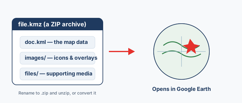
Double-click the file, and the placemarks, paths and imagery appear on the globe. Without the desktop app, open Google Earth for web and choose File, Import KML file. The Android and iOS apps open a KMZ as well, although a heavy file can struggle on a phone. QGIS reads a .kmz directly through Layer, Add Layer, Add Vector Layer, and ArcGIS Pro uses the KML To Layer tool. Converting to a shapefile or GeoPackage first is the better route when you plan heavy editing.
Way 2: unzip it to reach the KML
- Make a copy of the file, then rename
file.kmztofile.zip. - Extract the archive the way you would any ZIP.
- Find
doc.kmlin the extracted folder and open it in any text editor.
A rename that produces file.kmz.zip means Windows is hiding file extensions. Turn on File name extensions in the Explorer View tab, or skip the rename and open the .kmz directly with 7-Zip, WinRAR or Keka. The doc.kml inside is plain XML that follows the open OGC KML standard, so names, descriptions and coordinates can be edited in any editor. One caution when editing by hand: KML writes longitude first, then latitude, the reverse of how most people say it.
Way 3: convert it to the format you need
Viewing is often not the point, because the data is headed for a spreadsheet, a GIS layer or a web map. Pick the converter by destination, and everything below runs in your browser with nothing uploaded.
| You need | Convert to |
|---|---|
| Plain, editable KML | KMZ to KML (the KML/KMZ page runs both directions) |
| A spreadsheet of placemarks | KMZ to CSV or KMZ to Excel |
| A layer for ArcGIS or QGIS | KML/KMZ to Shapefile |
| A web map layer | KMZ to GeoJSON |
| A route for a GPS unit | KMZ to GPX |
The KML & KMZ converter covers the remaining outputs when none of these fit.
After converting, check three things
A conversion that ran is not the same as a conversion that worked, so give the output thirty seconds of scrutiny.
- The row count matches your placemarks, so nothing was silently dropped.
- The columns are real fields rather than one block of popup HTML, which means the attributes were lifted properly.
- The features land in the right place, which confirms the coordinates survived the trip.
“The reason double-clicking a KMZ sometimes does nothing is that it is a ZIP, not a document. Rename it to .zip, or just point Google Earth at it directly.”
Frequently asked questions
It opens but looks empty. Why?
The view is probably somewhere else. In Google Earth, right-click the layer and choose Zoom to. If it stays blank, the file may hold only a network link that points at a dead server.
Can I open a KMZ in Google Maps?
Yes, through Google My Maps. Create a map, click Import on a layer and upload the file. My Maps has per-layer feature limits, so a very large KMZ may need splitting or converting first.
Accents show as question marks. Why?
That is an encoding mismatch. KML is always UTF-8, so the output should use UTF-8 too. For a shapefile output, keep the .cpg file next to the .dbf.
What is the difference between KML and KMZ?
KML is an uncompressed XML text file. KMZ is a ZIP archive containing that KML plus any icons or overlay images it references. They hold the same data, and KMZ is simply smaller, which is why Google Earth exports it by default.
Can I open a KMZ in Excel?
Not directly, because Excel cannot read the zipped XML. Convert the KMZ to CSV or Excel first, and the placemark names, coordinates and popup attributes become ordinary spreadsheet columns.