
How to convert Excel to Shapefile
- Drop the .xlsx file; the first worksheet in the workbook is the one that is read.
- Confirm the latitude and longitude columns, or the WKT column; projected coordinates need their matching coordinate system.
- Choose Shapefile and convert, then unzip .shp, .shx, .dbf, .prj and .cpg.
What changes when you convert Excel to Shapefile
| What | Excel → Shapefile | |
|---|---|---|
| Geometry | Changes | Points, lines and polygons are all carried over, but a Shapefile holds a single geometry type per file. A layer that mixes types is written one type at a time. |
| Attributes | Changes | Every column is kept, but the Shapefile .dbf caps field names at 10 characters, so long names are shortened (values are untouched). |
| Styling & labels | Kept | Neither Excel nor Shapefile stores visual styling, so there is nothing to lose. Geometry and data carry straight over. |
| Coordinate system | Changes | Excel has no CRS. You can assign one before converting; otherwise the numbers are passed through and tagged WGS84. |
| Elevation (Z) | Not stored | Excel has no 3D geometry. An elevation column, if the table has one, rides along as an ordinary attribute rather than as Z height. |
| File structure | Changes | A working Shapefile is several files, so you download one .zip holding .shp, .shx, .dbf, .prj and .cpg. Keep them together. |
What your spreadsheet needs first
The workbook needs a latitude column and a longitude column in decimal degrees, or a single WKT column when the rows describe lines or polygons. Every other column, a site name, a parcel ID, a measurement, rides into the shapefile attribute table, trimmed only by the 10-character limit on field names. Reading runs on the first worksheet, so keep the rows you want converted on sheet one.
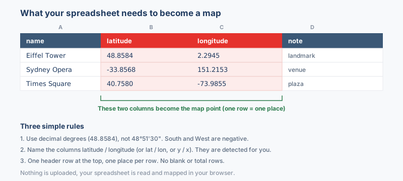
The columns that matter
- Latitude between -90 and 90, negative in the southern hemisphere, under a header such as
lat,latitudeory. - Longitude between -180 and 180, negative west of Greenwich, under a header such as
lon,lng,longitudeorx. - A WKT column when the sheet holds line or polygon geometry; each geometry type becomes its own shapefile inside the zip.
Write coordinates as decimal degrees, 33.6844 and 73.0479. A value such as 33°41'04"N is text to the converter, so run it through the coordinate converter first. Only .xlsx is accepted; an old .xls is rejected with a prompt to save it as .xlsx, and formulas are read at their computed values.
Why convert Excel to Shapefile?
Field crews, planners and analysts type addresses, parcel IDs and measurements into workbooks because typed cells are easy to maintain, and the master copy of a lot of site data lives exactly there. Converting reads the first worksheet of the workbook, takes each formula at its computed value, and turns the rows into a layer that opens in ArcGIS or QGIS like native data. Once unzipped, the layer behaves like any other shapefile, ready for joins, buffers and publishing through GeoServer.
Coordinate system handling
A spreadsheet has no coordinate system of its own. Excel rows are read as WGS84 longitude/latitude (EPSG:4326) unless you tell the tool otherwise. If your coordinates are projected, for example UTM eastings and northings in meters, pick the matching CRS before converting so the points land in the right place instead of near Null Island (how to find the EPSG code).
The coordinate system you choose is written into the Shapefile .prj file, so the layer opens in the right place in QGIS or ArcGIS. Pick WGS84 only if the values really are longitude and latitude.
What to check when converting Excel to Shapefile
Shorten your headers before converting, because the .dbf caps field names at 10 characters, so a header like SamplingLocationName is cut short and similar names can collide and be numbered. Only cell values cross over: charts, colors and cell formatting are dropped, rows without valid coordinates are left out, and an elevation column is kept as an attribute rather than as height. The values themselves are never cut, whatever happens to the names.
Troubleshooting Excel to Shapefile
- The file was rejected at the drop zone. Only .xlsx is accepted. An old .xls workbook is turned away with a message asking for a save as .xlsx, which File > Save As in Excel handles in seconds, and the data itself is unchanged by that save.
- Data from another sheet is missing. The first worksheet is the one that is read. Move or copy the rows you want converted onto the first sheet, or save that sheet as its own workbook, and convert again.
- The points come out on the wrong continent. Latitude and longitude are swapped in the pickers, or projected meters were read as degrees. Confirm latitude sits between -90 and 90, and give UTM or grid values their matching coordinate system before converting.
- Headers came through renamed or numbered. The .dbf caps field names at 10 characters, and duplicates created by the cut are numbered to stay unique. Give columns short, distinct names in Excel first when the labels matter downstream.
- Nothing converts even though the sheet looks full. Coordinate cells formatted as text read as empty. Reformat the two columns as numbers, confirm at least one row carries both values, then run the conversion again.
About the formats
Excel is where tabular site data usually lives, a workbook of typed cells that a surveyor or analyst edits by hand, while Shapefile is what desktop GIS expects to open. Converting from Excel to Shapefile turns spreadsheet rows into mapped features, so tools like ArcGIS or QGIS can style, label and query them. Your workbook supplies both the attributes and the coordinate columns, and the result is a proper GIS layer, ready for spatial work.
Frequently asked questions
Which coordinate system ends up written in the .prj file?
The one you choose; without a choice, the values are tagged WGS84, which is right only when they really are longitude and latitude in degrees. Pick the matching UTM zone or grid first when the sheet holds projected eastings and northings.
Can I make lines or polygons instead of points?
Yes, when one column holds the geometry as WKT text, because LINESTRING and POLYGON strings are rebuilt as real shapes, while latitude and longitude columns alone produce points.
Can points, lines and polygons share a single converted output?
Not inside one shapefile, since the format holds a single geometry type per file. A mixed sheet still converts in one pass: the result is one shapefile per geometry type, packed together inside the one zip.
Will my Excel formulas and formatting carry into the shapefile?
Formulas are read at their computed value, so the numbers in the .dbf match what the cells showed. Charts, colors and cell formatting have no place in an attribute table and are dropped on the way through.
Why is the result a zip instead of one file?
A shapefile is several files that must travel together: the .shp with the shapes, the .shx index, the .dbf with the attributes, the .prj with the coordinate system and the .cpg for encoding. Zipping them is what keeps the set complete between computers.
Related converters
The same spreadsheet can also become a KML for Google Earth, a compact KMZ, or a GeoJSON layer for web mapping. Every spreadsheet conversion is on the Spreadsheet to map tool.
Ready to convert?
Drop a file and download the result in seconds. Nothing is uploaded, nothing is stored.