
How to convert Excel to KMZ
- Drop the workbook and let the page read the rows.
- Assign the location columns if the automatic detection needs correcting.
- Choose KMZ and convert; the file is ready to email or open in Google Earth.
What changes when you convert Excel to KMZ
| What | Excel → KMZ | |
|---|---|---|
| Geometry | Kept | Each row with coordinates becomes a point feature. If the table has a WKT geometry column, its lines and polygons are rebuilt as real shapes. |
| Attributes | Kept | Every column and full field name moves from Excel into KMZ untouched. |
| Styling & labels | Changes | KMZ supports styling; features are written with clean default styling and a name label you can restyle in Google Earth. |
| Coordinate system | Changes | Excel carries no coordinate system, so values are read as WGS84 longitude/latitude (EPSG:4326), which KMZ requires. Set a source CRS if your data is in meters. |
| Elevation (Z) | Not stored | Excel has no 3D geometry. An elevation column, if the table has one, rides along as an ordinary attribute rather than as Z height. |
| File structure | Kept | One compact .kmz (a zipped KML), easy to email and quick to open in Google Earth. |
What your spreadsheet needs first
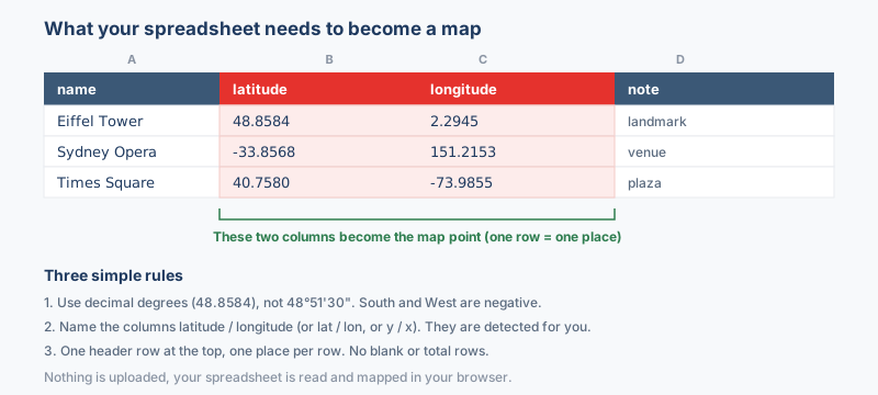
Whatever the sheet looks like, the result is one compact archive, so preparation is about making each row readable as a place. Two coordinate columns are the only hard requirement, and the rest of the row follows its placemark into the archive.
How the sheet is read
- Latitude under any clear header;
lat,latitudeandyare all found without help. - Longitude likewise;
lon,lng,longitudeandxare all understood. - A name column, so placemarks carry labels instead of anonymous pins in the Google Earth sidebar.
The old binary .xls format is not accepted; save such a workbook as .xlsx and nothing else about it has to change. Google Sheets users can take File, then Download, then Microsoft Excel, and convert that export directly.
Why convert Excel to KMZ?
Location data accumulates in Excel, with site visits, asset lists and survey points sitting in typed columns, and a spreadsheet cannot show any of it on a globe. Converting to KMZ turns each row into a placemark and wraps the whole map in one small file, the tidy way to share a working sheet as a Google Earth layer without sending the spreadsheet itself.
Coordinate system handling
No cell style marks a column as geographic, so coordinate columns are read as WGS84 degrees until a different system is chosen. Survey sheets in a national grid or a state plane zone hold values running into the hundreds of thousands, and those need their system declared up front, because numbers that large cannot be read as degrees at all.
The archive that comes back wraps a KML document, and that document is WGS84 because the Google Earth specification permits nothing else. Compression changes the byte count, never the geography, so the placemarks a colleague opens are positioned exactly as the rows declared them.
What to check when converting Excel to KMZ
Three checks before you convert save a second pass later. Coordinates should be decimal degrees, not projected meters and not text such as 33°41'04"N. Coordinate cells must hold numbers, since rows without valid coordinates are skipped and no placemark appears for them. Keep headers short and clear, because they become the field labels in the Google Earth balloon.
Troubleshooting Excel to KMZ
- The converted map shows an out-of-date version of the data. The first worksheet in the workbook is the one that gets read, and many files keep an old export or a summary tab in that slot. Drag the current sheet to the leftmost tab position, save, and convert again.
- Links built with HYPERLINK arrive as plain words. Formulas are read at their computed value, and for HYPERLINK that value is the friendly display text rather than the address. Put the raw URL in its own cell so the address itself reaches the balloon.
- Rows hidden by a filter still show up as placemarks. A filter changes what Excel displays, not what the sheet contains, and every data row is read regardless. Copy the visible rows to a fresh sheet, or delete the filtered-out ones, when the map should carry only the selection.
- The balloon lists 45017 where the visit date should be. Excel stores dates as serial day counts, and a date cell can reach the balloon as that bare number. Convert the column to ISO text with the TEXT function before converting, so each placemark carries 2026-04-01 rather than a serial.
About the formats
An Excel workbook keeps sites, sensors or survey stops one row each, with latitude and longitude columns alongside the notes. KMZ is the packaged form of that same list for Google Earth. Converting turns every row into a placemark, then zips the resulting KML so the finished map ships as one small file a colleague double-clicks to see the table sitting on the globe.
Frequently asked questions
Why does this page output KMZ rather than plain KML?
KMZ is the same KML zipped into one smaller file, which Google Earth opens by default. Choose Excel to KML instead when someone needs to edit the text.
My points landed in the sea, so what happened?
Latitude and longitude are almost certainly swapped, or the values are projected meters read as degrees. Check the column pickers and confirm latitude sits between -90 and 90.
Can I pull the data back out of the KMZ later?
Yes. KMZ to Excel turns the placemarks back into rows, with names, attributes and coordinates landing in columns again.
Will my other Excel columns show up when I open the KMZ in Google Earth?
Yes. Non-coordinate columns become attributes on each placemark, so clicking a point shows its details in the balloon. Charts and cell formatting are dropped, since only cell values are converted.
Related converters
Prefer editable output? You can convert Excel to KML instead, or map the sheet straight to a shapefile. To go the other way, turn a KMZ back into Excel. New to it? The guide on converting Excel to KMZ for Google Earth walks through every step, and the Spreadsheet to map tool handles CSV too.
Ready to convert?
Drop a file and download the result in seconds. Nothing is uploaded, nothing is stored.