Convert CSV to KMZ, the zipped flavour of KML that travels well by email and loads straight into Google Earth. Conversion and compression both happen in-browser; the point table itself is never uploaded.
Drop a file here, or click to browse
KML, KMZ, SHP (.zip), GeoJSON, GPKG, GML, GPX, DXF, CSV, Excel, and more
No CSV file to hand? Download a sample CSV file (100 points) and drop it above to see the conversion.
Every format stores different things, so a conversion is never perfectly loss-free. Here is exactly what carries over when you convert CSV to KMZ, and what to watch for.
| What | CSV → KMZ | |
|---|---|---|
| Geometry | Kept | Points, lines and polygons are preserved exactly, including multi-part shapes. |
| Attributes | Kept | Every column and full field name moves from CSV into KMZ untouched. |
| Styling & labels | Changes | KMZ supports styling; features are written with clean default styling and a name label you can restyle in Google Earth. |
| Coordinate system | Changes | CSV carries no coordinate system, so values are read as WGS84 longitude/latitude (EPSG:4326), which KMZ requires. Set a source CRS if your data is in metres. |
| Elevation (Z) | Kept | CSV is 2D, so there is no elevation to carry (add a Z/elevation column if you need one). |
| File structure | Kept | One compact .kmz (a zipped KML), easy to email and quick to open in Google Earth. |
You do not need to be a GIS expert to convert CSV to KMZ. Your sheet needs just two things: a column of latitudes and a column of longitudes, and each row then becomes a Google Earth placemark inside one compact file. Everything else, names, notes, dates, ID numbers, rides along as attributes on each point.
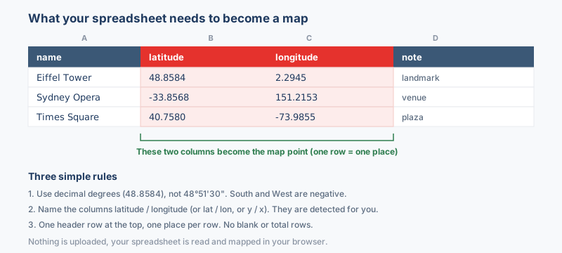
lat, latitude or y are detected automatically.lon, lng, longitude or x are picked up for you.Store the coordinates as plain decimal degrees, like 33.6844 and 73.0479. If your values look like 33°41'04"N instead, convert them first with the coordinate converter. CSV to KMZ works with .xlsx, .xls, .csv and Google Sheets exports, and if the wrong column is picked you can fix it from the dropdowns before converting.
People keep point data in CSV because spreadsheets are easy to edit. A CSV of addresses, sensor sites, or field readings sits happily in Excel or Google Sheets. However, a spreadsheet is hard to hand to someone who just wants to see the map. KMZ solves that. It wraps a KML document into a single compressed archive that Google Earth opens directly. So this conversion turns a working table into a finished, shareable map. For example, you can email one small KMZ of survey points, and the recipient sees placemarks on satellite imagery instead of columns of numbers.
A spreadsheet has no coordinate system of its own. CSV rows are read as WGS84 longitude/latitude (EPSG:4326) unless you tell the tool otherwise. If your coordinates are projected, for example UTM eastings and northings in metres, pick the matching CRS before converting so the points land in the right place instead of near Null Island.
KMZ is defined in WGS84 (EPSG:4326), so the output is reprojected to longitude/latitude, exactly what Google Earth and web maps expect. A quick CRS check before you download saves the classic "my CSV data is in the wrong place" surprise; the guide on coordinate systems and EPSG codes goes deeper.
Check that your CSV has real coordinate columns before converting. Each row needs latitude and longitude, or geometry stored as WKT. Rows without valid coordinates get skipped, so a typo or blank cell means missing placemarks. Also remember KMZ uses longitude and latitude in WGS84. So if your spreadsheet lists an easting/northing or a projected X/Y pair, the points will land in the wrong place.
CSV files typically come out of Excel, Google Sheets, QGIS, pandas. Once you convert to KMZ, the file opens in Google Earth Pro and Google Earth for web by a simple double-click, plus QGIS and ArcGIS Pro. The KMZ output follows the standard specification exactly, so those programs read it without any special import settings.
Here your starting point is a CSV, a plain table of rows that you likely built in Excel or Google Sheets. Each row needs latitude and longitude to become a mapped point. KMZ is the finished, zipped Google Earth deliverable. This pairing suits people who keep records in a spreadsheet but want to hand colleagues one compact file they can open on the globe. In practice, the CSV holds your working data, and the KMZ becomes the shareable result.
KMZ is a KML document packed inside a ZIP archive. That is the format itself, not extra compression, and Google Earth opens the .kmz directly without you unzipping it.
Yes. The other columns in each CSV row become attributes on that placemark, so clicking a point in Google Earth shows those values in its description bubble.
Your non-coordinate columns become each placemark's attributes, so clicking a point in Google Earth shows those values in its description bubble. Keep clear header names, because those headers become the field labels. The latitude and longitude columns are used to position the point and are not repeated as description text.
KMZ is a compressed archive that holds the KML document inside, so a large point set from your CSV downloads as one smaller file. Google Earth opens it directly with no unzipping step. If you later need the raw text, rename the file to .zip and extract the KML within.
A KMZ file opens in Google Earth by double-click, plus QGIS and ArcGIS. Because the output follows the standard specification, any tool that supports KMZ will read it without special settings.
No conversion is perfectly loss-free because each format stores different things, but geometry and attributes are preserved; only presentation-level styling (which KMZ does not store) is left behind.